Excerpt from Integrated Wireless Network Contract Task Orders
| C.1.10.2 |
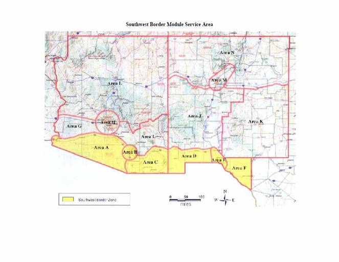
Coverage
The First Service Area is divided into six areas (A-F) bounded as follows:
Area A:
North: 10 miles north of and following the centerline of I-8 in Arizona; and then 10 miles north of and following the centerline of I-10 east of its intersection with I-8
South: Southwestern Arizona border with Mexico, and Southeastern California border with Mexico East: Area B; and south of Area B, the eastern boundary is 10 miles west of and following the centerline of I-19 West: 15 miles radius surrounding the location defined by latitude N32.677450, longitude W114.620157 (Yuma), extending into California but not Mexico
Area B:
Area C:
North: 10 miles north of and following the centerline of I-10 in Arizona South: Southeastern Arizona border with Mexico East: Arizona-New Mexico state line West: Area A and Area B
Area D:
North: 10 miles north of and following the centerline of I-10 in New Mexico South: Southwestern New Mexico border with Mexico East: Area E West: Arizona-New Mexico state line
Area E:
North: 30 mile radius surrounding the location defined by latitude N32.323700, longitude W106.756674 (Las Cruces, NM) South: Southwestern New Mexico border with Mexico, and Southwestern Texas border with Mexico East: 30 mile radius surrounding the location defined by latitude N32.323700, longitude W106.756674 (Las Cruces, NM); 30 mile radius surrounding the location defined by latitude N31.849250, longitude W106.437549 (El Paso, TX), but not extending into Mexico; and 30 miles east of the line connecting these two locations (along the line) West: 30 miles west of the line connecting the locations defined by latitude N32.323700, longitude W106.756674 (Las Cruces, NM) and latitude N31.849250, longitude W106.437549 (El Paso, TX)
Area F:
North: Texas-New Mexico state line South: Southwestern Texas border with Mexico East: Eastern border of Hudspeth County West: Area E
|